Google Launches AI Travel Enhancements for Search and Maps

I am a law graduate from NLU Lucknow. I have a flair for creative writing and hence in my free time work as a freelance content writer.
I am a law graduate from NLU Lucknow. I have a flair for creative writing and hence in my free time work as a freelance content writer.


I am a student pursuing my bachelor’s in information technology. I have a interest in writing so, I am working a freelance content writer because I enjoy writing. I also write poetries. I believe in the quote by anne frank “paper has more patience than person
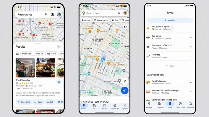
The phase of quarantine is becoming very challenging with every passing day. But, the ones who are at home should consider themselves lucky because that’s all it takes to be safe. We should be grateful to all the police officers and medical professionals who are risking their lives to save the world. But, amongst all this chaos, our heart still longs for something extra. The memory of your last pizza bite might have just started fading. Yes, craving for good food has become a real struggle these days. But, at any cost, we shouldn’t step out of the house. Many online food delivery companies are primarily keeping their services close. Because let’s admit it the emergency services are what we need in this hour. But, it seems like Google has paid heed to the Monday blues or in this case quarantine blues. So, Google Map launched new shortcuts in its app to help people find takeouts from where food delivery service is available. Google’s new announcement has turned out to be a lifesaver for millions of people. Especially for those who weren’t able to come home due to the lockdown.
It will remain questionable if Google was already planning to release this new feature. But, even if it wasn’t, there could not be any perfect timing. People are locked up in their houses, especially the hostellers and young employees. No one but them used to be dependent on the service of online food delivery. So, they will be highly benefited by this. And, the common people would also like the taste of something different during this monotonous life.
The
Indian government has done a very appreciable job by collaborating with Google.
This new feature has highlighted the shortcut button on the main user interface
of the app. Previously Google Map already had the feature of showing the
nearest restaurants, coffee shops, gas stations, etc. But, the highlighted
option for takeout and delivery is what recently been added.
The
COVID-19 pandemic followed by the lockdown has pushed Google to do it. Because
when many people casually use the app, they may skip out this small button at
the corner. But, now it will be of utter advantage to the people of India. The
new feature will show all the takeouts near your location that can provide
delivery. Apart from India, this new feature is also available in the United
States and some other countries.
This
new feature is not only for relishing good restaurant foods at home. It will
also help deliver food at your doorsteps during the time of emergency. The
Indian government in collaboration with Google India and Smart Cities has
decided to launch this new feature. In the beginning, 31 cities all over the
nation will get access to this feature.
The
Google Map app will show Public Food shelters and Public Night shelters. This
will improve the condition of feeding the nation’s people. The options of “Food
shelter near me” and “Night shelter around me” will pop up on the screen. From
here one can proceed to order food.
Well, you should know one thing that Google Map already had the option of takeaways. But, what is new is the highlighted shortcuts. Some people might have the confusion which Google has cleared. The process of ordering is pretty simple. You go to the app and select the area where you want to check the service of takeaway and delivery. It’s up to you which service you are going to take.
But,
it’s better to not step out of your house. So, delivery will be a safe option
for everyone. After the area is selected, the particular shortcut will display
the entire list of restaurants near the selected area. It will only show the
locations that can provide either takeouts or delivery. In the case of foreign
countries, clicking a particular restaurant can send you to the website of
GrubHub. From there you can order food and enjoy your meal.
But, in
India order can be directly accepted in most restaurants from Google Maps. The
shortcuts are made available on iOS, iPad, and Android.

Annasha Dey is an NIT student, who apart from studying engineering is also a content writer. She has a great interest in photography, writing, reading novels, and travelling as well. She is a foodie who loves socializing and hanging out with her friends. She is also a trained Kathak dancer and a big fashion enthusiast. Dey also loves watching TV series, which includes F.R.I.E.N.D.S. and Big Bang Theory. To be a better writer she prefers to read more
Before settling down in the technical sector of Google and long before founding ‘Where 2 Technologies’, all the four founders of Google Map, Noel Gordon, Stephen Ma and the Rasmussen brothers, Lars and Jens, had totally divergent lifestyles. Initially, they had no plans on starting something of their own, but they somehow ended up creating a Sydney-based digital mapping start-up, ‘Where 2 Technologies’, which came under the acquisition of Google after a year of its launch.
Noel Gordon, Stephen Ma, Lars Rasmussen and Jens Rasmussen are the founding members of Google Map. The story starts with the Rasmussen brothers, at the time, when they started from zero with a sky-high dream of becoming millionaires, later, joined by Gordon and Ma.
Before Founding Where 2 Technologies
Born in Denmark, Lars always wanted to become a veterinarian. But, his mindset was changed after a terrible incident happened when he was 13. The Rasmussen brothers started taking programming lessons after school. Lars graduated with a PhD in Theoretical Computing in 1998 and moved to the US in 2000. In the US, he worked for a company, prior to dot-com boom in Silicon Valley. Dot-com or Dot-com Bubble was a business model that was followed by many companies to expand rapidly and capture the market.
After the stock market crashed in the year 2000 (also known as the dot-com boom), the Rasmussen brothers went through a $45 million loss in start-up capital. Though it was a major loss, they didn’t consider giving up as an option. With no savings and a mere $16 in their pockets, they started thinking of building a start-up. After the dot-com bust, the two needed to come up with something very unique, and something which, people would be interested to invest in. They started to work with mapping and navigation systems, to create something unusual and to set their application apart from already existing mapping software. And that is how they developed the idea of Where 2 Technologies, one of the most widely used platforms for navigation.

After six months of diligent hard work, they finally had a prototype to show and went to meet Frank Marshall, a private investor, to discuss fundings. Marshall was a very influential person, and it was him, who set all the meetings between Rasmussen brothers and high profile investors.
Where 2 Technologies really started taking shape after the other two founders joined Rasmussen brothers in the venture. Before joining Where 2 Technologies, Ma worked at a petrol station, and Gordon worked in his father-in-law’s clothing factory.
The Real Struggle
When the two bothers were still struggling with the idea of a new mapping system, Lars flew to Australia to live with his girlfriend. In Australia, Lars sought out Gordon and Stephen, when the brothers were already bankrupt. Then, with a little funding from Gordon, Where 2 Technologies was actually created and started shaping towards perfection. The team worked in the spare bedroom with conditions led by Gordon’s girlfriend. They didn’t work after 5, and also, spared the weekends. Gordon, in one of his interviews, said that they might be the only start-up in the entire world that worked from 9 to 5.
The next step was to get the right investors for the idea. They jot down the list of potential competitors, list of buyers, capital firms and technical strategies for Where 2 Technologies. By this time, they were already living lives with maxed out credit cards, but the zeal to achieve the goal was untamed. After showing a few prototypes to some of the huge investors, the real deal began when they had to represent the idea of advanced digital mapping to Google’s co-founder, Larry Page.
At first, Where 2 Technologies created an application for mapping which was supposed to be downloaded, installed, and then used for navigation. But Google wasn’t interested in application software, so it gave the team a deadline to get an idea for a web browser. Within a time span of only three weeks, they required to create a prototype, and that is how the scribbled whiteboard became famous. Finally, the team was able to successfully deliver it in August 2004. And with an unrevealed sum, Where 2 Technologies came under the acquisition of Google. This was Google’s second acquisition.
The Triumph
Even before the founders could embrace success, they found themselves working as Google employees. These Nooglers, that is, new recruits of Google started working at the Australian headquarters of the company. The company launched its IPO soon after they were recruited, where Google valued $23 billion. Among the four of them, Gordon still works at Google, and Ma retired a few years ago.
Google Map was founded on 8th February 2005, and by 2012, the company had over 2,100 employees working in the mapping sector.
The hard work of those four men paid off well because they were never ready to give up.
Annasha Dey is an NIT student, who apart from studying engineering is also a content writer. She has a great interest in photography, writing, reading novels, and travelling as well. She is a foodie who loves socializing and hanging out with her friends. She is also a trained Kathak dancer and a big fashion enthusiast. Dey also loves watching TV series, which includes F.R.I.E.N.D.S. and Big Bang Theory. To be a better writer she prefers to read more
The tech giant Google has been continuously working towards improving its services for its consumers. Similarly, for its most widely used GPS app, Google map, Google has been adding new features to it to make navigation simpler for its users.
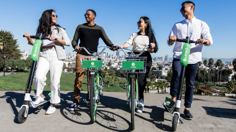
Google has already added Uber to its Google Map app, from where the users can book cabs for them. Now on Thursday, Google announced that it is going to partner with Lime and will show the location of nearby Lime battery-powered scooters, on Google Map. Google is planning to do so, in order to shorten the commute times for its users, as they will be able to rent those ride from the app.
Google, in its blog, said that after getting out of a taxi or a subway, the 15 minutes walk can be reduced to a smaller ride with the help of those scooters. Google will now display the nearby Lime scooters on the Google Map app, as another transport option, and after the users tap on it, they will be redirected to the Lime app. If there is no lime app on their smartphones, they will be redirected to the Apple Store or Play Store, so that they can download the app. And then, the users can book those scooters and bikes, from the app.
For now, the service will be available only in thirteen cities worldwide, i.e., Auckland (NZ), Austin, Baltimore, Brisbane (AU), Dallas, Indianapolis, Los Angeles, San Diego, Oakland, San Antonio, San Jose, Scottsdale, and Seattle. And, after the successful testing of the services, Google is planning to expand it into other cities as well.
The app not only will show the distance of the vehicle form users’ location but also will display the total journey time, battery consumption, the total cost for the journey and the number of other Lime vehicles nearby.
Lime, in the time of its 14 months operation, has fulfilled almost 1.5 million bike and scooter rides and has raised $467 million in funding to date, Google’s parent company, Alphabet, being one of the biggest investors in it. The partnership between the two companies is not only beneficial for them business-wise, but will be a great contribution in reducing the congestion and carbon emissions.

Yashica is a Software Engineer turned Content Writer, who loves to write on social causes and expertise in writing technical stuff. She loves to watch movies and explore new places. She believes that you need to live once before you die. So experimenting with her life and career choices, she is trying to live her life to the fullest.