Your Tech Story

google maps

Google Maps

Google Maps for iPhone will Now Let You Report Incidents Like Traffic Jams and Crashes

Despite being the biggest player in the smartphone industry, the iPhone users still rely on Google Maps when it comes to finding direction to a location or see for the traffic on the way, instead Apple having its own map app. This is only because of the high tech methods, Google has been using to provide the mapping services to the users. Now, the company has brought another set of updates to improve its services on Google Maps for the iPhone.

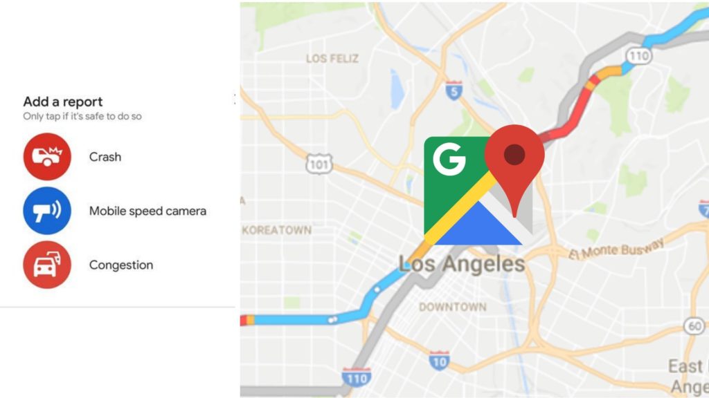
Among the new updates, the company has announced a new feature that will allow the iPhone users to report the incidents from the road to Google Maps, like any road blockage, construction, accident, traffic or any other driving hazards, which will reflect on the screens of other people when commuting on the same route.

The feature is inspired by Google’s navigation app Waze, which the company bought five years ago paying 1.1 billion. On Waze, people are already able to track and report the mentioned incidents, and we can see that Google is trying to slowly migrate those features to its Google Maps app. In fact, Google has already added similar features to its Android Google Maps App and people has received it quite well.

Google Maps

In recent months, the company has been making new changes to the app to improve its functionalities. Also, in May this year, 40 countries received the speed limits and speed trap alerts feature on the Android Google Maps app. The company even introduced features that would allow the users to add stoppage in between their route while using the navigation on the map.

To use the latest feature on the iPhone’s Google Maps app, one while following the navigations on the map can tap on a button under the compass on the map. The app will list various options, like Crash, Speed Trap, Slowdown, Construction, Lane Closure, Disabled vehicle and Object on Road, and the user will need to select one of the options to report the incident.

The new feature though will help the other users to track the traffic or blockage on the road due to any of the reasons, and change their route, but it will be more beneficial for Google in terms of collecting data and improving its services.

Google Maps Comes With a New Feature ‘Stay Safer’ for the Indian Users

The ride-hailing services like Uber and Ola have been already providing the safety features over the apps, and now for the first time, Google Maps is going to introduce a safety feature for the Indian users. The new safety feature is called ‘Stay Safer’ and will be another India-first feature.

Google map stay safer
Image Source: zeebiz.com

Though people are already able to track their path through the Google Map, the new Stay Safer feature, will notify the users if they are on the right path or not, while riding a taxi or an autorickshaw. The users will also be able to share the live status of their trip, similarly as they can using an Uber and Ola app, with their family members or friends.

“Through our extensive research across India, we found that a lot of people limit their mobility due to safety-related concerns. To address this, we are launching another India-first feature that will deliver a more relevant and reliable experience to our users. Our new ‘Stay Safer’ feature on Google Maps will alert users who are travelling in taxis, auto-rickshaws etc. in case their vehicle goes off route, giving them peace of mind.” said Amanda Bishop, the Product Manager at Google Maps, while announcing the new feature on Wednesday.

How to Use the New Stay Safer Feature on Google Maps

The feature has already been launched for Android, and the users will now be able to see it on the updated Google Map app. To use Stay Safer, the users need to select a destination, where they want to go. Like earlier, the users will get to choose the direction and will see the shortest path to the destination. Now with the ‘Start’ option, they will also be able to see the ‘Stay Safer’ option. Upon clicking the option, they will further see two more options ‘Share Live Trip’ and ‘Get Off-route Alerts’.

By choosing the first option, there will appear multiple options to share the trip status with their contacts, like Hangouts, Whatsapp, Facebook, Gmail, Instagram, etc.

With the ‘Get Off-route Alert’, the users will be able to get the notification on whether they are following the right path or have got off the route. If they will get an off-route notification from Google Maps, they can share their live location with their contacts for any emergency.

The feature is another India-first feature after Google Map recently launched three new India-focussed public transport features including the live train status, bus, auto-rickshaw and public transport total travel time calculated by looking at the live traffic.

Google Maps Releases New Public Transport Features for its Indian Users

Google Maps has been one of its kind and the best tracking app to look for the distance between two locations, get directions, and track the traffic in between the travel. But now Google is moving forward and is bringing features like tracking any delay in the train timings to Google Maps for its Indian users. Along with tracking the live train status, the company has also introduced two new features, i.e. mixed-mode directions and live traffic tracking.

google maps
Image Source: dailypioneer.com

To track the live status of the trains, the company will be working with Indian Railways, through the startup, Where is My Train, that it had acquired last year. The startup app had tied up with Indian Railways and provided the live status of trains to its users, i.e. the delays in the train timing, that too, on the offline mode.

Now, as Google has integrated this feature to Google Maps, the users will be able to track which trains they can choose to travel between two specific locations, where the train is, and the timing of leaving from or reaching a particular platform, etc.

Also, the Mixed-mode direction feature of the app will now provide users with better options for travelling in local places. The commute suggestions will now combine auto-rickshaw and public transport, along with option like travel through car, two-wheelers, bus or taxi. In fact, it has not been much time, since the company had included the two-wheelers to its travel option in the app.

The app has already been used for finding the right path to travel. So like before, it will show the total time to reach a destination highlighting the traffic. And this time, while tracking the transit, the users when running on time will see time in green, and when delayed, they will see the time in red in the app.

India will be the first country to host these new features of Google Maps, and the company intends to expand the same in the other countries of South Asia, America and some of the African countries, soon. Google considers India as one of its biggest consumers, and for now, it will roll out the features for the cities, such as Delhi, Bangalore, Mumbai, Hyderabad, Pune, Lucknow, Chennai, Mysore, Coimbatore, and Surat.